
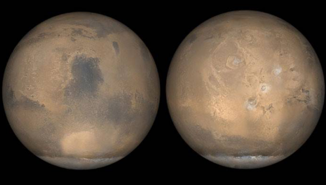
Global images of Mars taken by the Mars Global Surveyor (MGS) during summer in the planet’s northern hemisphere. Between 1997 and 2006, MGS looked at Mars in unprecedented detail, building upon the successful Viking missions before it.
Credits: NASA/USGS
Mars Global Surveyor examines the Red Planet in unprecedented detail.
On September 11, 1997, NASA’s Mars Global Surveyor (MGS) spacecraft reached Mars, completing a 435-million-mile journey that began 10 months earlier at Cape Canaveral Launch Complex 17A. The next day, the spacecraft was placed into a highly elliptical orbit around the Red Planet, coming as close as 163 miles to the surface and as far away as 33,570 miles.
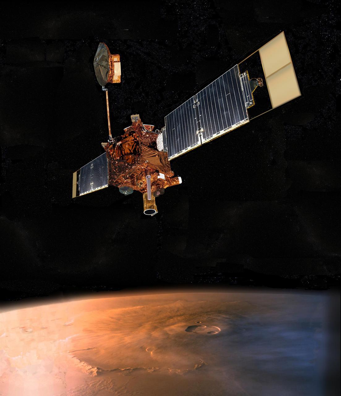
An artist concept of NASA Mars Global Surveyor (MGS) flying over Mars.
Graphic Credits: NASA/JPL-Caltech
The spacecraft performed a series of dips into the planet’s atmosphere, using the atmospheric drag on the deployed solar arrays to alter the spacecraft’s orbit in a technique known as aerobraking. After an issue was discovered with one of the arrays and its yoke, the team refined the aerobrake procedure to reduce stress on the vital components and still refine the spacecraft’s trajectory into a nearly circular orbit. Between September 17, 1997, and February 19, 1999, the team reduced MGS’s orbital period from 44.9 hours to less than 2 hours.
NASA’s Magellan spacecraft had demonstrated the potential of aerobraking in the thick atmosphere of Venus in the summer of 1993, but MGS was the first spacecraft to employ the technique at Mars and it became a pathfinder for future missions. The use of aerobraking meant MGS didn’t need to carry the additional 3,300 pounds of propellant that would have been required to refine the orbit solely using thrusters.
MGS arrived at Mars 21 years after Viking 1 and Viking 2. Its science objectives were built upon the success of the Viking missions, which used orbiters and landers to explore Mars in greater detail than ever before. The Viking orbiters mapped nearly 97 percent of the planet’s surface and returned 52,633 images. The landers took panoramic images of the surface, measured the temperature, and collected and analyzed the first Mars soil samples.
The Mars Global Surveyor was 10 feet long and weighed 2,342 pounds at launch. The main bus of the spacecraft was 4 feet by 4 feet. With the solar panels deployed shortly after arriving in space, MGS was 40 feet across and communicated with Earth via a high-gain antenna mounted on a 6.5-foot boom. During the spacecraft’s 2-hour orbit of Mars, it traveled over the planet’s north and south poles, taking high-definition images from about 250 miles above the surface.
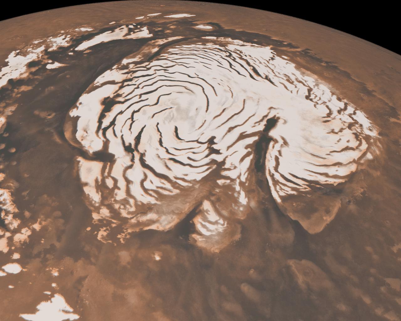
This image, combining data from two instruments aboard NASA’s Mars Global Surveyor, depicts an orbital view of the north polar region of Mars. To the right of center, a large canyon, Chasma Boreale, almost bisects the white ice cap.
Credit: NASA/JPL-Caltech/MSSS
MGS carried a suite of instruments to gather data about Mars, including an ultra-high-resolution camera capable of photographing objects less than 2 feet across on the Martian surface, a thermal emission spectrometer to quantify the atmosphere and analyze infrared radiation to map the mineral composition of the surface, a laser altimeter to measure the depth and height of geologic features, a magnetometer to gather data about the planet’s magnetic field, and a radio relay system.
NASA’s goals for the mission included characterizing the valleys, mountains, and plains of Mars at high spatial resolution, learning more about the mineral composition of the surface and the larger geological processes at work, understanding the gravitational field of Mars, monitoring global weather there, and learning about the thermal properties of the thin Martian atmosphere.
MGS operated at Mars for more than nine years, returning valuable data and images that changed scientific understanding of the planet. Images showed dry surface gullies, marked by deposits of dirt and rock, features consistent with rapidly flowing water at some time in the planet’s past. Decades later, NASA’s Perseverance Rover is exploring one such area, Jezero Crater, a large impact crater marked by a fan-delta, deposits of clays and carbonates, and other features that signal there likely was plentiful surface water there in the planet’s distant past—more than 3.5 billion years ago.
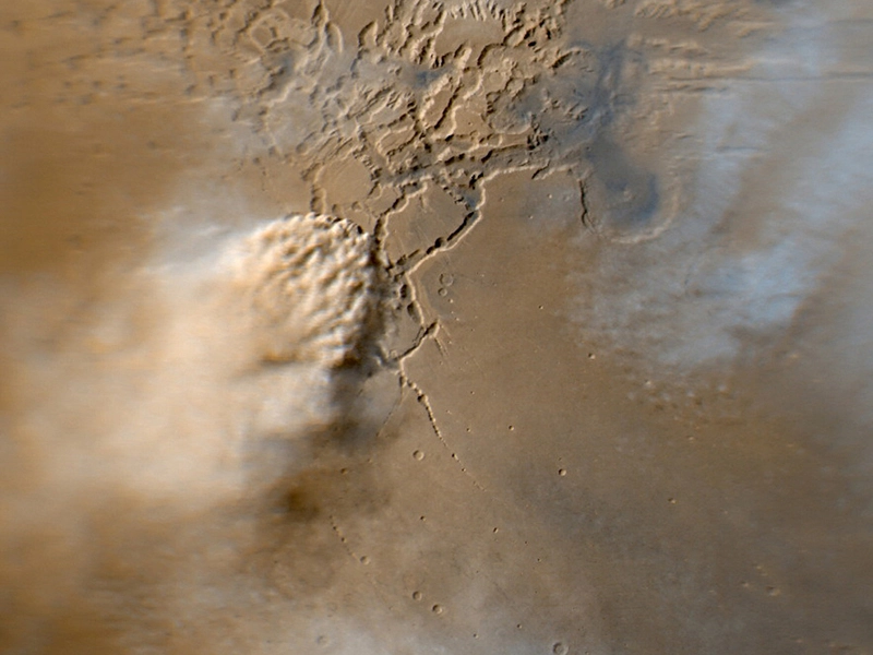
This image shows a turbulent mass of thick, roiling, red Martian dust rising from a network of canyons and flowing diagonally toward the lower left corner of the frame.
Credit: NASA
With MGS, NASA was able to track the evolution of a dust storm on Mars for the first time. The storms are an annual occurrence, with some growing as large as a continent on Earth and a rare few continuing to grow beyond that until they encircle the planet. The mission developed the first three-dimensional maps of the planet’s North Pole and returned detailed topographical data for much of the planet. The mission also revealed that Mars has a magnetic field that is localized and features multiple magnetic anomalies.
When the spacecraft’s primary mission ended in early 2001, NASA extended the work of the orbiter several times before losing contact with it in 2006.
“It is an extraordinary machine that has done things the designers never envisioned despite a broken wing, a failed gyro, and a worn-out reaction wheel. The builders and operating staff can be proud of their legacy of scientific discoveries and key support for subsequent missions,” said Tom Thorpe, then the Mars Global Surveyor Project Manager, in a 2006 statement.
“Mars Global Surveyor has surpassed all expectations,” said Michael Meyer, then NASA’s lead scientist for Mars exploration at NASA Headquarters, in a 2006 NASA press release. “It has already been the most productive science mission to Mars, and it will yield more discoveries as the treasury of observations it has made continues to be analyzed for years to come.”