
Researchers working with the NASA Earth Applied Sciences Disasters program area used satellite data to map buildings and infrastructure that were likely damaged in Houma, Baton Rouge, and other regions in central and western Louisiana due to Hurricane Ida. Ida struck southeast Louisiana as a powerful Category 4 Hurricane on Aug. 29, 2021, bringing destructive storm surge, high winds, and heavy rainfall to the region, and leaving over 1 million customers without power.
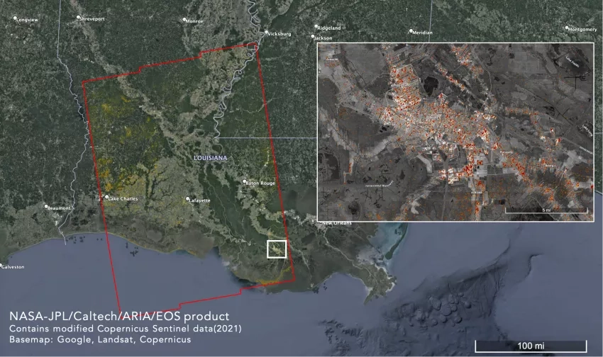
Scientists from the Advanced Rapid Imaging and Analysis (ARIA) team at NASA's Jet Propulsion Laboratory, the California Institute of Technology in Southern California, and the Earth Observatory of Singapore (EOS), created this Damage Proxy Map (DPM) depicting areas that are likely damaged by Hurricane Ida in central and western Louisiana, United States. The map was created by comparing Copernicus Sentinel-1 synthetic aperture radar (SAR) data from before (Aug. 10 and Aug. 22, 2021) and after (Sept. 3, 2021) Ida made landfall. The Copernicus Sentinel-1 satellites are operated by the European Space Agency (ESA), and the work was funded in part by the NASA ROSES A.37 research project “Global Rapid Damage Mapping System with Spaceborne SAR Data.”
The satellite data covers an area of 210 by 155 miles (337 by 250 kilometers), shown by the large red polygon. The inset image zooms in on the city of Houma, Louisiana, to show a detailed look at the damage the satellites detected. According to media reports, Houma suffered extensive damage from the heavy winds brought by Ida, with power poles knocked over, glass storefronts blow out, and roofs torn off. As of Sept. 4, the power, water and sewer systems in Houma were all non-operational. There was also extensive damage to the Houma-Terrebonne Airport.
In the image, each pixel of damage detection measures about 98 feet (30 meters) across. The color variation from yellow to red indicates increasingly more significant surface change, which can indicate damage to buildings and infrastructure. The data underwent a preliminary validation by comparing it with media reports of damaged areas. This damage proxy map can be used as guidance to identify damaged areas, but may be less reliable over vegetated or flooded areas. For example, the scattered colored pixels over vegetated areas and flooded fields may be false positives, and the lack of colored pixels over vegetated areas does not necessarily mean no damage. Some additional false positives in the middle of the image are likely due to the stitching together of multiple Sentinel-1 frames, seen as a thin line running across the map at an east/northeast - west/southwest angle. This map is most sensitive to damage to larger-scale buildings and infrastructure, but small-scale changes or partial structural damage may not be detected by this map.
Interactive version of the Damage Proxy Map from the NASA Disasters Mapping Portal. Click here to view fullscreen. Credits: NASA JPL / ARIA / Earth Observatory of Singapore (EOS). Copyright contains modified Copernicus Sentinel data (2021) processed by the ESA.
This Damage Proxy Map, along with other Earth-observing imagery produced in support of Hurricane Ida, is made freely available for researchers and responders in standardized Geographic Information Systems (GIS) format on the NASA Disasters Mapping Portal. NASA has unique capabilities to monitor disasters from an integrated Earth systems perspective, and is leveraging these capabilities and expertise to provide support for response and recovery efforts from Hurricane Ida. NASA continues to monitor the impacts from Ida and is working with national and regional stakeholders to provide them with the tools they need to make informed decisions for disaster response and recovery. Learn more.
Related Impact


