Dr. Beach’s Top 10 Beaches of 2021
For more than 30 years, Dr. Beach, aka Dr. Stephen Leatherman, has created an annual Top 10 Beach list. A professor and coastal geomorphologist at Florida International University, Dr. Beach factors in 50 different criteria including water color, sand softness, wave size, water temperature and more.
As we get ready to launch Landsat 9 this fall, we’re taking a tour of Dr. Beach’s Top 10 US beaches of 2021 as seen by Landsat 8.
10. Coast Guard Beach, Cape Cod, Massachusetts

Coast Guard Beach is located just north of the remote Nauset Inlet on Outer Cape Cod, Massachusetts. Except for the picturesque old white Coast Guard station that still sits atop the glacial bluffs, there is no development here; the best way to reach this beach is by bicycle from the Salt Pond Visitor’s Center or shuttle bus.
First mapped by Champlain in 1605, the shifting sands of this inlet are clearly visible in the Landsat image. This location is also at the point where the glacial sea cliffs transcend into a barrier beach (e.g., sand spit) that provides protection for the lagoon and development of lush salt marshes.
“In my early days as a Professor at Boston University and later at the University of Massachusetts at Amherst, I spent many summer and some winter-time days conducting scientific studies along this barrier beach.” – Dr. Beach
Landsat 8 collected this image of Coast Guard Beach on May 1, 2021.
9. Beachwalker Park, Kiawah Island, South Carolina

Beachwalker Park is a public beach located on the southern part of Kiawah Island, South Carolina. This barrier island in the Charleston area is 10-miles long and features a fine grained, hard-packed beach that can be traversed easily by bicycle.
This Landsat image shows a huge accumulation of sand as a series of shoals on the south end of the island, which can be reached from Beachwalker Park. These sandy shoals will eventually coalesce, becoming an extension of the sand spit that is the south end of Kiawah Island.
“In the early 2000s, I served as the beach consultant to the Town of Kiawah Island because their world-famous golf course on the north end was being threatened by severe erosion. It was necessary to artificially bypass some sand on the north end of the island so that the normal flow of sand along the island was reinstated, saving the outermost link of this PGA golf course.” – Dr. Beach
Landsat 8 collected this image of Beachwalker Park on April 9, 2021.
8. Coronado Beach, San Diego, California

Coronado Beach in San Diego is the toast of Southern California with some of the warmest and safest water on the Pacific coast. This 100-meter-wide beach is an oasis of subtropical vegetation, unique Mediterranean climate, and fine sparkling sand.
The harbor serves as a major port for the Navy’s Pacific fleet, the home port for several aircraft carriers. The docks and the crossing airplane runways for the Naval base are visible in this Landsat image.
“I really enjoy visiting this beautiful beach as well as having lunch and drinks, taking advantage of the hotel’s beachside service.” – Dr. Beach
Landsat 8 collected this image of Coronado Beach on April 23, 2020.
7. Caladesi Island State Park, Dunedin Clearwater, Florida

Caladesi Island State Park is located in the small town of Dunedin on the Southwest Florida coast. The stark white undeveloped beach is composed of crystalline quartz sand which is soft and cushy at the water’s edge, inviting one to take a dip in the sparkling clear waters.
While island is still in the Park’s name, Caladesi is no longer a true island as shown on the Landsat image–it is now connected to Clearwater Beach.
“Caladesi is located in the Tampa area, but it seems like a world away on this getaway island.” – Dr. Beach
Landsat 8 collected this image of Caladesi Island State Park on April 9, 2021.
6. Duke Kahanamoku Beach, Oahu, Hawaii

Duke Kahanamoku Beach is named for the famous native Hawaiian who was a big-board surfer and introduced surfing as a sport to mainland Americans and indeed the world.
One of the prominent features on this Landsat image is Diamondhead with its circular shape near the coast. This large cone of an extinct volcano provides the iconic backdrop for photos of Waikiki Beach.
“This is my favorite spot at the world-famous Waikiki Beach where you can both play in the surf and swim in the calm lagoonal waters.” – Dr. Beach
Landsat 8 collected this image of Duke Kahanamoku Beach on May 17, 2020.
5. Lighthouse Beach, Buxton, Outer Banks of North Carolina
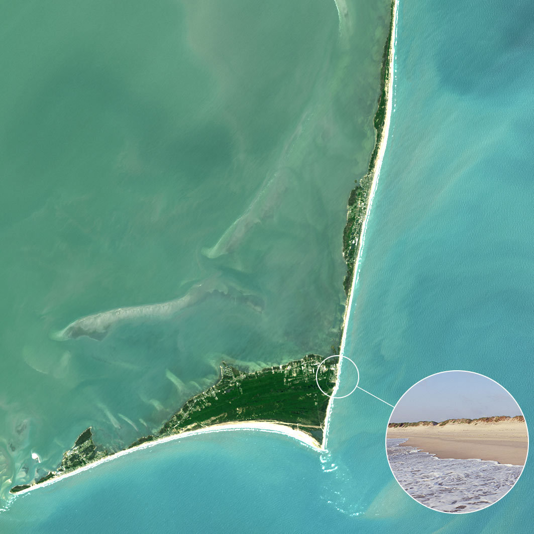
Lighthouse Beach in the village of Buxton is located at Cape Hatteras, the most northern cape in the Outer Banks of North Carolina. This lifeguarded beach is the number one surfing spot on the US Atlantic Coast as the large offshore sand banks, known as Diamond Shoals, cause wave refraction focusing wave energy on this beach.
The Landsat image shows the seaward growth of south flank of Cape Hatteras as evidenced by the parallel lines of beach ridges.
“It is fun to walk down the narrow sand spit, more exposed at low tide, as waves are approaching from both directions because of the bending of the waves.” – Dr. Beach
Landsat 8 collected this image of Lighthouse Beach on May 3, 2020.
4. St. George Island State Park, Florida Panhandle

St. George Island State Park, located on the Florida panhandle and far from urban areas, is a favorite destination for beachgoers, anglers and bird watchers as nature abounds. Like other beaches on the panhandle, this long barrier island has a sugary fine, white sand beach.
In this Landsat image, St. George can be seen north of the bridge that links this barrier island to the mainland. The enclosed bay behind St. George Island is fairly shallow and the water much less clear as shown on the Landsat image, but it is not polluted.
“Besides swimming in the crystal-clear Gulf of Mexico waters, I enjoy beachcombing and shelling. While this island was hit hard in 2018 by Hurricane Michael, it has substantially recovered as there was little development to be impacted.” – Dr. Beach
Landsat 8 collected this image of St. George Island State Park on October 13, 2020.
3. Ocracoke Lifeguard Beach, Outer Banks of North Carolina

Ocracoke Lifeguarded Beach at the southern end of Cape Hatteras National Seashore was the first seashore to be incorporated into the National Park Service system.
The Landsat image shows Ocracoke to the north as separated by an inlet from Portsmouth Island. The village of Ocracoke was built at the wide area of the island where it was protected from oceanic waves during coastal storms which include both winter nor’easters and hurricanes.
“Ocracoke was once the home of the most infamous pirate Blackbeard and is still a very special place—my favorite getaway beach.” – Dr. Beach
Landsat 8 collected this image of Ocracoke Lifeguard Beach on May 3, 2020.
2. Cooper’s Beach, Southampton, New York

Cooper’s Beach in the tony town of Southampton on the south shore of Long Island, New York is shielded from the cold Labrador current, making for a fairly long summer swimming season. The white quartz sand is medium to coarse grained with some pebbles, making the beach slope fairly steeply into the water.
This Landsat image shows the fairly large coastal pond named Mecox Bay to the east with Shinnecock Inlet and Bay also displayed to the west. Coopers Beach is hundreds of yards wide, made of grainy white quartz sand and is backed by large sand dunes covered by American beach grass.
“I spent several decades conducting scientific studies of this very interest oceanic shoreline because it is so dynamic and the beachfront real estate so expensive. Some of the most gorgeous and expensive residential houses in the United States are located in the world-famous Hamptons.” – Dr. Beach
Landsat 8 collected this image of Coopers Beach on August 30, 2019.
1. Hapuna Beach State Park, Big Island Hawaii
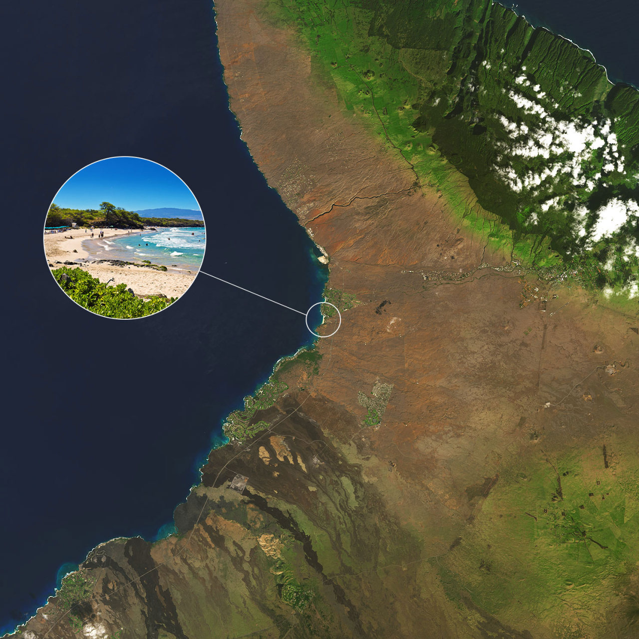
Hapuna Beach State Park is a white coral sand beach that resides in a landscape dominated by dark brown lava flows on the Big Island of Hawaii. The crystal-clear water is perfect for swimming, snorkeling, and scuba diving during the summer months in contrast to winter big-wave days when pounding shorebreaks and rip currents make swimming impossible.
Hapuna and the other pocket beaches appear as an oasis in this otherwise fairly bleak landscape except for the areas irrigated as prominently shown on the Landsat imagery by the green vegetation.
“This volcanically active island is the only place that I know where you can snow ski at the high mountain tops and water ski in the warm ocean water on the same day.” – Dr. Beach
Landsat 8 collected this image of Hapuna State Park on January 5, 2021.
What’s your favorite beach?
View Dr. Beach’s 2021 picks and see Landsat views of these beaches over time.
Make sure to follow us on Tumblr for your regular dose of space!