T-1: Since the Beginning

Since before the first Earth Day fifty years ago, NASA has had eyes on our planet from space. A few years before the first Earth Day, our very first weather satellites captured images of clouds moving in Earth’s atmosphere. Today, a constellation of satellites generates near-real-time images of precipitation around the globe.

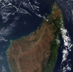
Shortly after the first Earth Day, NASA and U.S. Geological Survey researchers were preparing to launch the first Earth Resources Technology Satellite, later named Landsat 1, to collect images of the land. Now, engineers are building and preparing to launch Landsat 9 to continue that record.

A few years after the first Earth Day, the Nimbus-7 satellite imaged changing sea ice in the Arctic and Antarctic. Now, NASA has a 40-year record of sea ice extent at both poles.

NASA logo with the blue circle replaced with EarthThese are just a few of the many ways our view of Earth has sharpened since the first Earth Day.

T-2: Faces of Technology

Jackie Quinn had an idea. What if the system NASA developed for removing contaminants from building paint could also be used to clean up the environment? The engineer demonstrated NASA resourcefulness, starting out with a couple of plastic drinking straws she grabbed from a cafeteria at the agency’s Kennedy Space Center in Florida.

To remove PCBs from paint and other elements in its buildings after hurricane damage in the early 2000s, Kennedy devised a system that uses a benign reagent, or a reaction-causing substance, to attract and trap the contaminants. Quinn wanted to see if the technique could be adapted to get the contaminant out of the water near the buildings, too. As a first attempt, she heat-sealed the ends of her drinking straws, filled them with the reagent, capped them and placed them in a liquid containing PCBs.

It worked in a matter of hours.

T-3: A Peaceful Look Home

Have you ever enjoyed the beauty of nature on a long afternoon? For astronauts like Andrew Morgan, the work on the Space Station is intense, but it comes with some of the most relaxing views imaginable – our home planet, seen from low Earth orbit.

Even while he’s relaxing, though, Morgan is working. The photos he’s taking are breathtaking, and they’re also part of a research effort: the Crew Earth Observations investigation. His pictures will help us understand how our planet is changing over time.

NASA logo with the blue circle replaced with EarthYou can partake in that view without doing any work, though. So sit back, relax, and enjoy a truly out-of-this-world view of our shared home.

T-4: Tracking Wildlife from Space

Image Courtesy Heather Lynch

NASA and wildlife may not be an obvious pairing, but researchers and conservationists around the world are using data and images from NASA satellite instruments to manage and track living creatures of all kinds.

A scientist at Stony Brook University in New York is using a program that analyzes NASA satellite imagery to help track the movement of penguins in Antarctica. Conservationists in Kenya are finding new habitats for endangered black rhinos by using a tool that helps them track changes to landscapes in NASA satellite images. A Yale University a professor is integrating NASA satellite data into a critter-tracking program called the Map of Life.

We’re even working to protect animals right in our own back yard at Kennedy Space Center in Florida. Yes, the same NASA center that launches rockets to space is also home to sea turtles, alligators and beach mice.

T-5: Earth Day at Home

Even though we’re socially distant right now, we’re still connected to each other and our planet. On this 50th anniversary of Earth Day, NASA has put together a collection of activities, videos, posters and other resources to help you observe “Earth Day at Home,” wherever that may be. Many resources are available in English and Spanish.

Look at Earth from space and the ground – and learn how to make your own GIF using satellite data. Learn about our interconnected water, land and air from NASA experts, and watch a stunning visualization about 50 years of Earth science. Listen to astronauts talk about what it’s like to see Earth from space, and join scientists in a discussion about living in isolation in Antarctica.

NASA logo with the blue circle replaced with EarthAnd, find engaging games and science activities you can do easily at home. You can share images of how you observed Earth Day using #EarthDayAtHome on social media.

T-6: Sharing Your World

T-6: Sharing Your World

NASA’s Worldview app lets you explore Earth as it looks right now or 20 years ago. Through an easy-to-use map interface, you can watch tropical storms develop; track the movement of icebergs; and see wildfires spread and grow. Pan-and-zoom to your region of the world to not only see what it looks like today but also to investigate changes over time. Worldview’s nighttime lights layers provides a truly unique perspective of our planet under the cover of darkness.

NASA logo with the blue circle replaced with EarthWhat else can you do with Worldview? Add imagery layers by discipline, natural hazard, or key word to learn more about what’s happening on this dynamic planet. View Earth’s frozen regions with the Arctic and Antarctic views. See a view you like? Take a snapshot or create an animated GIF to share with your friends — and the world with #EarthDayAtHome!

T-7: Earth Phases

When Apollo 8 astronaut William Anders snapped the iconic Earthrise image, it captured the imagination of the people on Earth and helped inspire the first Earth Day. It’s a beautiful image and reminds us how fragile our home planet is.

Earthrise also showed us Earth like we’d never really seen it before, as a far-off world rising in the night sky – the way the Moon usually does. Seen from the Moon, Earth goes through the same phases the Moon does here, from crescent to full, illuminated by the Sun.

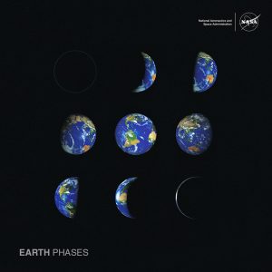
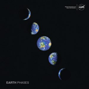
In honor of Earth Day, we’ve created downloadable posters that show Earth’s phases as seen from the Moon, including the big day on April 22, 2020. We also have a poster showing the layers of Earth and Earth’s atmosphere.

T-8: Water for Crops

As the climate of our home planet changes, some places are drying out and others are getting wetter, including the land producing the food we eat.

NASA’s fleet of satellites has watched over Earth for more than half a century, collecting valuable agriculture data. This allows scientists to monitor farmland – tracking the overall food supply, where specific crops are grown and how much water it takes to grow them, with data from the joint NASA/USGS Landsat satellites and others. With that information, farmers can find new ways to grow more crops with less water.

NASA logo with the blue circle replaced with EarthIt’s more important than ever for farmers to adapt farming practices to a warming world. The data collected by our Earth-observing fleet helps farmers learn about the planet that sustains us – and make better decisions about how to cultivate it.

T-9: The Sounds of Earth

Close your eyes and think about your favorite place on our home planet. For many NASA Earth scientists, their favorite place is the one they’ve spent years studying – like the Amazon rainforest. Bright colors, the sounds of animals and an understanding of just how alive Earth is.

Today, NASA’s Curious Universe podcast travels to the Amazon with Earth scientist Doug Morton and to Los Angeles with carbon cycle scientist Annmarie Eldering.

NASA logo with the blue circle replaced with EarthDoug studies how fires are changing Earth – satellites are often the first to spot fires burning in remote regions of the planet. Those fires can release carbon dioxide and other pollutants into the air. NASA satellites help study pollutants, too, all part of studying Earth as an interconnected system – the only place like it that we know of.

Listen to the full episode here.

T-10: Building Solutions with Space Apps

USGS/NASA Modis satellite image of Madagascar, featured in SkyWatch Gallery: https://www.skywatch.com/gallery.

NASA’s International Space Apps Challenge is the largest global hackathon, inviting people across the globe to use NASA’s open data to build innovative solutions to challenges we face on Earth and in space. Space Apps 2019 had more than 29,000 participants from 71 countries!

Over the years, Space Apps participants have submitted more than 9,000 projects that grapple with the planet’s toughest problems. Winners from 2019 created applications to fight dengue, combat wildfires, detect oil spills, predict algal blooms, and clean the ocean.

Some teams have gone on to form their own companies! In 2014, one Toronto-based team created SkyWatch, which makes Earth observation data more accessible by aggregating it into a single platform.

Space Apps 2020 is scheduled for Oct 2-4, and we need you! Follow the challenge on Facebook and Twitter, and apply to host an event in your city: https://www.spaceappschallenge.org/.