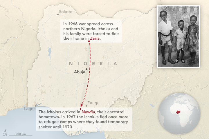
The Ichokus traveled nearly 700 kilometers (400 miles) in search of refuge. The photograph was taken in front of the Ichoku home circa 1962 and shows Charles (center) with his siblings, Emeka and Mary. (NASA Earth Observatory map by Joshua Stevens. Photograph courtesy of Charles Ichoku.)
For three years, Ichoku, his parents, and five brothers and sisters holed up in remote schools that had been converted into refugee camps. The forest cover around the camps and villages was dense enough to ward off advancing ground troops; it did not necessarily deter aircraft or missiles. Life was strange. Schools were closed; food was almost always scarce.
In the midst of war, Ichoku took solace in the natural world. "I was attracted to the order I found in nature," he said. "Things fit together in a way that made sense."
Nearly 50 years later, Ichoku still finds himself looking for order and sense in nature, though for very different reasons and from a very different perspective. As a senior scientist at NASA’s Goddard Space Flight Center, Ichoku uses satellites to study fires. His latest project has brought him back to the region where he grew up, a place where more fires burn per square kilometer than virtually anywhere on Earth.
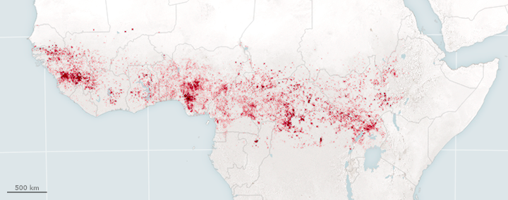
The Suomi NPP satellite detected these fires (red dots) in Africa on January 30, 2016. Ichoku hypothesizes that such fires play a significant role in altering rainfall patterns. (NASA Earth Observatory map by Joshua Stevens, using VIIRS data from Suomi NPP.)
Ichoku’s aim is to understand if those fires—most of which are lit by farmers and herders—might be contributing directly or indirectly to changing rainfall patterns in the region. He also wonders if the fires are exacerbating drought, a menace that has devastated the region several times since the 1970s.
While war and violence have intruded on Ichoku's life once again—slowing down and hampering his research—he has begun the painstaking process of gathering enough evidence to convince himself and others that fire, drought, and famine are connected.
Ichoku’s project focuses on a semi-arid to semi-humid swath of Africa, south of the Sahara Desert but north of the equator. It stretches from Senegal and Liberia on the west coast to Eritrea and Somalia in the east. The northern half of the region, known as the Sahel, is dry most of the year, with almost all of the rain falling during May and June. The amount of rainfall varies sharply with latitude, with the northernmost part of the Sahel receiving less than 200 millimeters (8 inches) of rain per year and the southern parts (in West and Central Africa) receiving up to 2000 millimeters (79 inches).
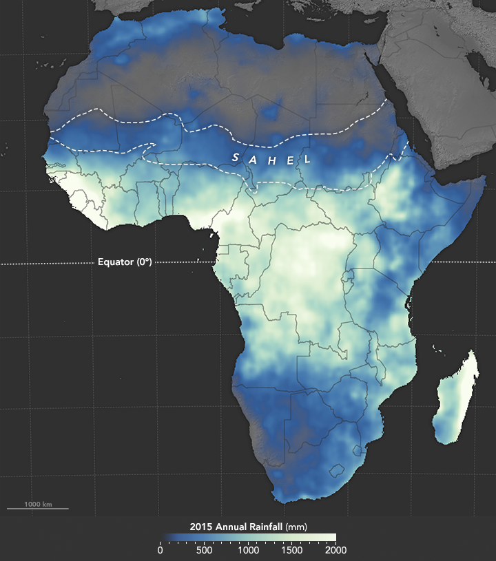
While rains soak central Africa, the northern and southern ends of the continent remain relatively dry throughout the year. (NASA Earth Observatory map by Joshua Stevens, using data from the African Flood and Drought Monitor.)
Some 58 million people live in the Sahel, but demographers expect the population to continue growing in the coming decades, with upwards of 200 million people living there by 2050. Most of the people rely on subsistence farming for food. But with soils of marginal quality, and with most farms entirely dependent on rainfall for watering the crops, growers face long odds even during good years.
Those odds grew even longer in the 1960s when wet season rains became less reliable. In countries where poverty is widespread and societal safety nets are weak, a few dry years can easily lead to food shortages and famine. Between 1968 and 1972, hundreds of thousands of people in the Sahel died of starvation, and tens of millions were displaced due to food shortages.
Dry periods in the 1980s were just as devastating, with millions of people dying during droughts in Kenya and Ethiopia. The rains improved somewhat after 1990, but unusually dry years now alternate erratically with unusually wet ones, swinging the Sahel between feast and famine. As recently as 2012, a drought-triggered famine left 15 million people in the Sahel malnourished.
For decades, meteorologists and climatologists have been looking for clues about what causes the Sahel’s droughts. The evidence points to both natural and human culprits.
The most important natural factor seems to be a cyclical shifting of ocean temperatures in the North Atlantic. Every three decades or so, the North Atlantic switches from being dominated by a patch of relatively warm water to having a patch of relatively cool water—a phenomenon that climate scientists call the Atlantic Multi-decadal Oscillation (AMO).
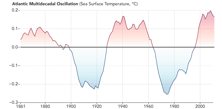
Sea surface temperatures in the Atlantic periodically rise and fall over several decades, creating a pattern known as the Atlantic Multi-decadal Oscillation. This pattern occurs in the North Atlantic even as global sea surface temperatures are steadily increasing. (NASA Earth Observatory chart by Joshua Stevens, using sea surface temperature data from NOAA.)
The reasons for this swap are poorly understood, but the consequences for the Sahel are not. When the North Atlantic is warm, large-scale weather patterns shift and bring more rain to the Sahel; when the North Atlantic enters a cool phase, the rains stay just to the south of the Sahel. During the worst droughts between 1960 and 1980, the North Atlantic was in a cool phase. The Sahel has been warmer and wetter since 1990, but there are hints now that the North Atlantic may be cooling again, meaning drought could return in coming years.
On top of this natural variability, some scientists have hypothesized that the way humans use and alter the landscape is also important. In 1975, Massachusetts Institute of Technology scientist Jules Charney published a study (using a global climate model developed at NASA’s Goddard Institute for Space Studies) arguing that the presence or absence of vegetation can play a critical role in exacerbating droughts. In the case of the Sahel, he argued that human activity—specifically overgrazing—was making the dry years even drier.
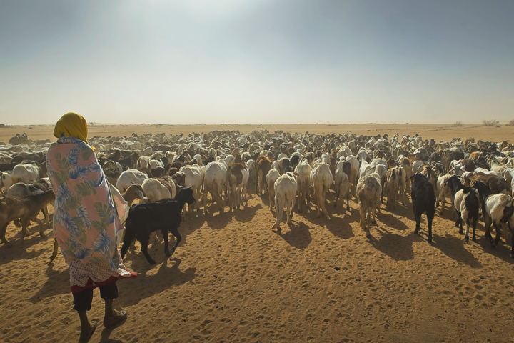
A shepherd leads a herd of goats and sheep to a grazing area in eastern Chad. Overgrazing can reduce vegetation in already sparsely vegetated areas, exacerbating dryness in these regions. (Photo by European Commission/DG Echo, adapted under a Creative Commons license.)
The argument looks like this: Grazing animals clear the land surface of vegetation, which makes it harder for the soil to retain moisture. Grazing also makes the surface more reflective by replacing relatively dark vegetation with relatively bright desert soil. A more reflective surface means that more heat from the Sun reflects back into space, rather than warming the surface. In turn, this makes the atmosphere more stable by limiting convection, the process of heat rising in the atmosphere. Soil moisture and convection are both key ingredients that trigger rainstorms. Without them, Charney argued, rains would be less likely to form.
If Charney’s theory is correct, then it could set up a vicious cycle that would reinforce itself. Grazing would lead to less vegetation and perhaps less rain, which would lead to even less green vegetation and more deserts, which would lead to even less rain.
While Ichoku believes that the AMO and over-grazing arguments have merit, he thinks there’s another factor that deserves recognition and study: fire. Every November through April, Earth-observing satellites detect a tremendous band of fire that stretches across the semi-arid to semi-humid swath of sub-Saharan Africa. Most fires start during the dry months of December and January, and scattered fires sometimes linger into the onset of the rainy season in April and May. Almost all of these fires are lit by people as they work to clear and fertilize fields for crops or to encourage the growth of forage for animals. In some areas, fire is also used as a tool to herd prey.
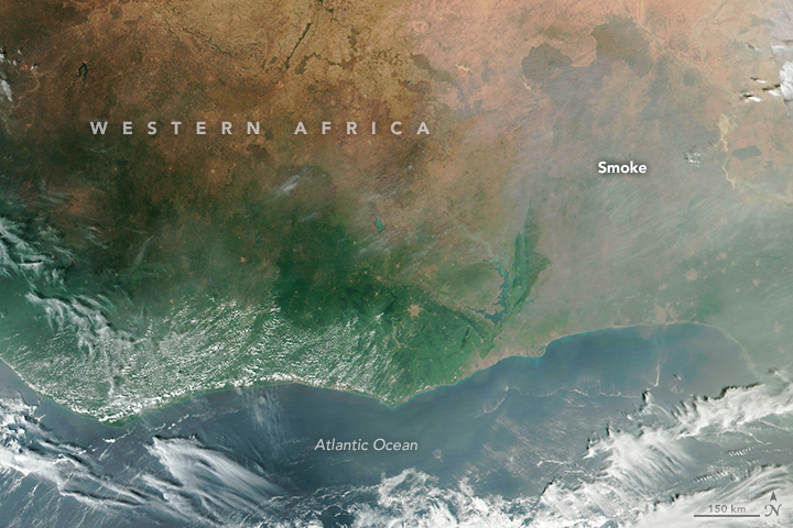
Numerous fires create a smoky pall over the skies of western Africa. The image above was acquired on December 10, 2015. (NASA Earth Observatory image by Joshua Stevens, using VIIRS data from Suomi NPP.)
It was in the late 1990s that Ichoku first began to think fires might be affecting rainfall patterns and exacerbating droughts in the Sahel and surrounding regions. Satellite observations were growing more accessible and abundant, and they were revealing incredible numbers of fires. Though the Sahel was showing some signs of recovery from an extreme drought, Lake Chad was on the verge of disappearing. This sprawling wetland and shallow lake—a key water source for millions of people in Niger, Nigeria, Chad, and Cameroon—covered about 25,000 square kilometers in 1960. By 1980, it spanned just 1,500 square kilometers. (The lake has since recovered slightly and fluctuates year to year, but today it only covers about 2,500 square kilometers.)
In 2002, Ichoku read an article in New Scientist reporting on drought and famine in the Sahel, and he wondered if the many fires in his childhood homeland were accelerating changes in land cover, surface albedo, and other conditions...and warding off the rains. It made intuitive sense because fire clears vegetation and dries out the surface, much like grazing animals do.
Around the same time, he became aware of new research showing that airborne particles, or aerosols, could reduce or prevent precipitation in some circumstances. In fact, the building blocks of clouds—tiny spheres of water called cloud droplets—can only form if they are "seeded" by certain types and sizes of aerosol particles.
Normally, cloud droplets get bigger and wetter as water molecules attach to them, accumulate, and become raindrops. However, the new research showed that an abundance of aerosols—such as plumes of dust or smoke—meant that many more cloud droplets would form. With the same amount of moisture to distribute across all of these cloud droplets, those droplets would remain small and immature rather than growing into raindrops. In essence, clouds that form in the presence of smoke and dust aerosols are less likely to produce rain.
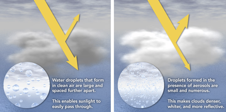
The presence or absence of aerosols can influence the size and density of water droplets. In turn, the translucency, color, and reflectivity of the clouds is affected by airborne particles. This is known as the cloud albedo affect. (NASA Earth Observatory illustration by Robert Simmon.)
While he would have liked to design experiments to test the idea, Ichoku was busy at the time with many other projects at NASA’s Goddard Space Flight Center, especially validating observations of fires and aerosols from newly-launched Moderate-Resolution Imaging Spectroradiometers (MODIS) on NASA's Terra and Aqua satellites.
Then in 2009, an opportunity to study the water-cycle impacts of fire finally presented itself. Ichoku pulled together a multidisciplinary team of hydrologists, land-cover experts, atmospheric scientists, earth system modelers, climatologists, and fire experts from Goddard, the University of Missouri, the University of Maryland, Howard University, the University of Nebraska, and the Desert Research Institute. He also found collaborators in Africa.
Ichoku and colleagues broke the problem down into its component parts. Ichoku analyzed ten years of satellite records of land-cover change, rainfall, soil moisture, vegetation health, and fires near the Sahel. Other colleagues examined how fires affect the albedo, or reflectivity, of the Earth. Others used atmospheric models and satellite observations to better understand what happens when smoke and clouds mix.
When Ichoku matched fire activity to hydrological indicators observed by satellites, he found that the links between fire and rain became clearer. For instance, in years when there was severe burning during the dry season, measurements of soil moisture, evaporation, and the abundance of green vegetation—all of which help spur rain—dipped during the following wet season.
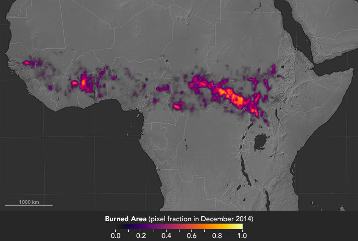
Fire detections from satellites allow scientists to determine when—and where—burning happens. In the map above, burning is depicted as the proportion of a 0.25° pixel identified as burned. (NASA Earth Observatory map by Joshua Stevens, using MODIS fire detection data from the Global Fire Emissions Database at Oak Ridge National Laboratory.)
Other members of the team started investigating how such fire effects would alter atmospheric models of rainfall patterns. They explored how fires release tiny particles of black carbon that can warm the atmosphere and burn off cloud cover in certain circumstances; essentially, the smoke and heat disrupt the upward movement of moisture and can cause precipitation to develop later in the day, or not at all.
Despite many tantalizing hints, there are still many questions. For instance, even though the number of fires decreased throughout the region by 2 to 7 percent each year between 2006 and 2013, there was not a corresponding increase in precipitation. Rather, overall precipitation varied significantly from year to year. Discrepancies like this underscore that fire activity is not the only factor affecting precipitation, noted Ichoku.
One of the more interesting and alarming trends he found was that even as fire activity decreased overall, it increased noticeably in the wetlands around Lake Chad—one of the areas that contributes significant amounts of moisture to the atmosphere. "It may be that the location of the fires and where they are burning—in a wetland versus dry savanna—are as important as the overall number of fires," Ichoku said.
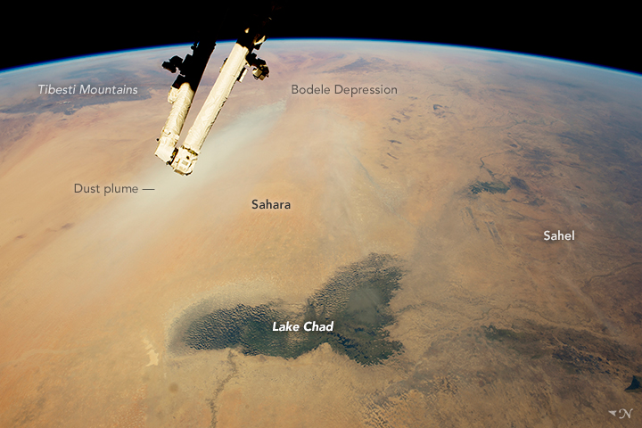
Lake Chad is a prominent feature of the African landscape, situated between the dry Sahara and semi-arid Sahel. (Astronaut photograph ISS042-E-244403 was acquired on February 12, 2015 and is provided by the ISS Crew Earth Observations Facility and the Earth Science and Remote Sensing Unit, Johnson Space Center.)
His colleagues agree that there is plenty to learn. "We have found some evidence of interesting and potentially important relationships between biomass burning and hydrology. However, the linkages are complex and still under investigation," said Eric Wilcox, an atmospheric scientist at the Desert Research Institute. "One complication is that the biomass burning occurs primarily during the dry season, while the precipitation occurs during the wet season. Our analysis so far is indicative of changes in hydrology that may be related to biomass burning, but on-going modeling will hopefully provide a clearer picture."
Ichoku sees enough connections between fires and the water cycle to be convinced that the problem must be studied more aggressively. "We found hints that the fires are inhibiting rainfall with this project," said Ichoku. "Now maybe our team or the broader scientific community will leverage these hints and find some answers to the lingering science questions." We need more modeling and more observations on the ground to confirm some of the things that we have started to see in the satellite data."
To bring "ground truth" to what they could see from space, Ichoku and colleagues planned to visit the Lake Chad Basin. They wanted to set up a small network of weather stations and ground-based sensors that would monitor soil moisture and groundwater, but their plan was quickly complicated by a situation reminiscent of the strife Ichoku faced in his childhood. Parts of the Lake Chad Basin have become a war zone. Since 2009, Boko Haram—a terror group based in northeastern Nigeria—has mounted an insurgency against the governments in the region and has tried to establish an anti-Western Sharia-law state. The region has been plagued by kidnappings, bombings, and gun battles.
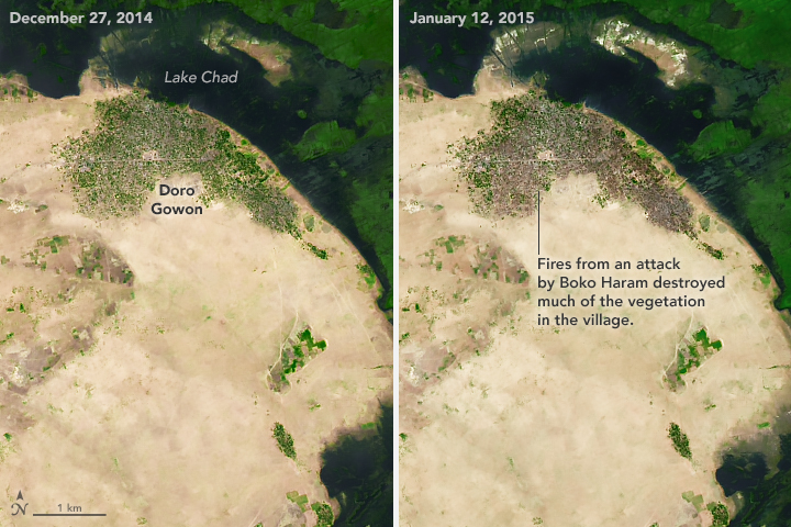
Boko Haram fighters attacked the Nigerian village of Doro Gowon in early 2015. Fires from the fighting destroyed numerous structures and much of the vegetation, revealed in these shortwave infrared images before and after the attack. (NASA Earth Observatory images by Joshua Stevens, using Landsat data from the U.S. Geological Survey.)
So for several years, Ichoku’s request to travel to Lake Chad was denied by U.S. authorities because of the risks posed by Boko Haram, as well as the Ebola epidemic in some African countries. When Ichoku finally got permission to travel to N’Djamena (Chad’s capital) in 2015, he was not allowed to stray far from the city because Boko Haram controlled areas near his field sites. He could not get to many of the places where he had hoped to install sensors and conduct field studies with members of the Lake Chad Basin Commission. He had to rely on colleagues to install much of the gear, and even that was difficult. About half of the sensors suffered technical problems due to the harsh climate. One sensor was stolen.
"It was frustrating, but we did get some data from some stations," Ichoku said. "That was critical because it helped us ground-truth the satellite observations and modeling work we were doing."
The challenges with the ground sensors are indicative of the worldwide challenges of conducting scientific research in a region where poverty and security remain stubborn problems. "As a scientist working in America, I am so privileged and fortunate," Ichoku said. "Meanwhile, the environmental challenges the Lake Chad Basin faces are staggering. But in many cases, observing networks are extremely limited or non-existent, and science is still given a very low priority by the people and the decisionmakers."
Though the funding for his project is officially winding down, Ichoku is not done. He is now working to train a group of scientists in West Africa to continue the research. With support from the West African Science Service Center on Climate Change and Adapted Land Use (WASCAL), he is planning an educational workshop for 35 scientists to be held in Ghana in June 2017.
"The idea is to build up the capacity of local scientists," said Ichoku. "Many of them are not aware that satellite sensors such as MODIS and VIIRS are making daily observations of fires, and that the data is free to use and open to all. We hope to train some of these promising young scientists on how to use the tools and data."
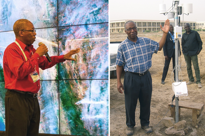
Left: Ichoku presenting his research on the NASA hyperwall. Right: Ichoku stands next to a weather station and soil moisture probe that he helped install during a 2015 field campaign in N'Djamena, Chad. (Photographs courtesy of Charles Ichoku.)
Ichoku is also figuring out how to provide better tools and data sets to help the local governments manage what remains of Lake Chad. Major decisions loom, including a controversial plan to replenish the lake by building a channel from the Ubangi River in the Central African Republic.
"Considering where I started, I never would have imagined I would be blessed and fortunate enough to end up at NASA," said Ichoku. "I have seen directly how much good exposure to science has brought to my life. Now I can only hope that applying a scientific mindset to some of the issues facing the people living in the Lake Chad Basin will bring some good to that region as well."
