The First Photo From Space
In 1946, rocket-borne cameras gave us our first look at Earth from beyond the atmosphere
/https://tf-cmsv2-smithsonianmag-media.s3.amazonaws.com/filer/33/d1/33d15156-47cd-4307-9c23-e3c8498539f5/1stphotofromspacejpg__600x0_q85_upscale.jpg)
On October 24, 1946, not long after the end of World War II and years before the Sputnik satellite opened the space age, a group of soldiers and scientists in the New Mexico desert saw something new and wonderful—the first pictures of Earth as seen from space.
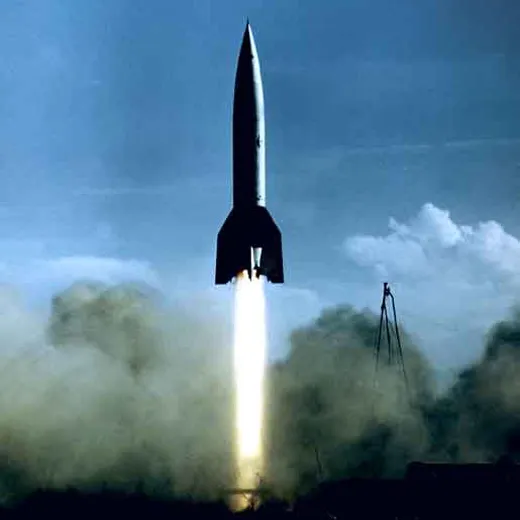
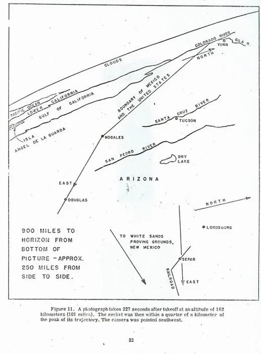
The grainy, black-and-white photos were taken from an altitude of 65 miles by a 35-millimeter motion picture camera riding on a V-2 missile launched from the White Sands Missile Range. Snapping a new frame every second and a half, the rocket-borne camera climbed straight up, then fell back to Earth minutes later, slamming into the ground at 500 feet per second. The camera itself was smashed, but the film, protected in a steel cassette, was unharmed.
Fred Rulli was a 19-year-old enlisted man assigned to the recovery team that drove into the desert to retrieve film from those early V-2 shots. When the scientists found the cassette in good shape, he recalls, "They were ecstatic, they were jumping up and down like kids." Later, back at the launch site, "when they first projected [the photos] onto the screen, the scientists just went nuts."
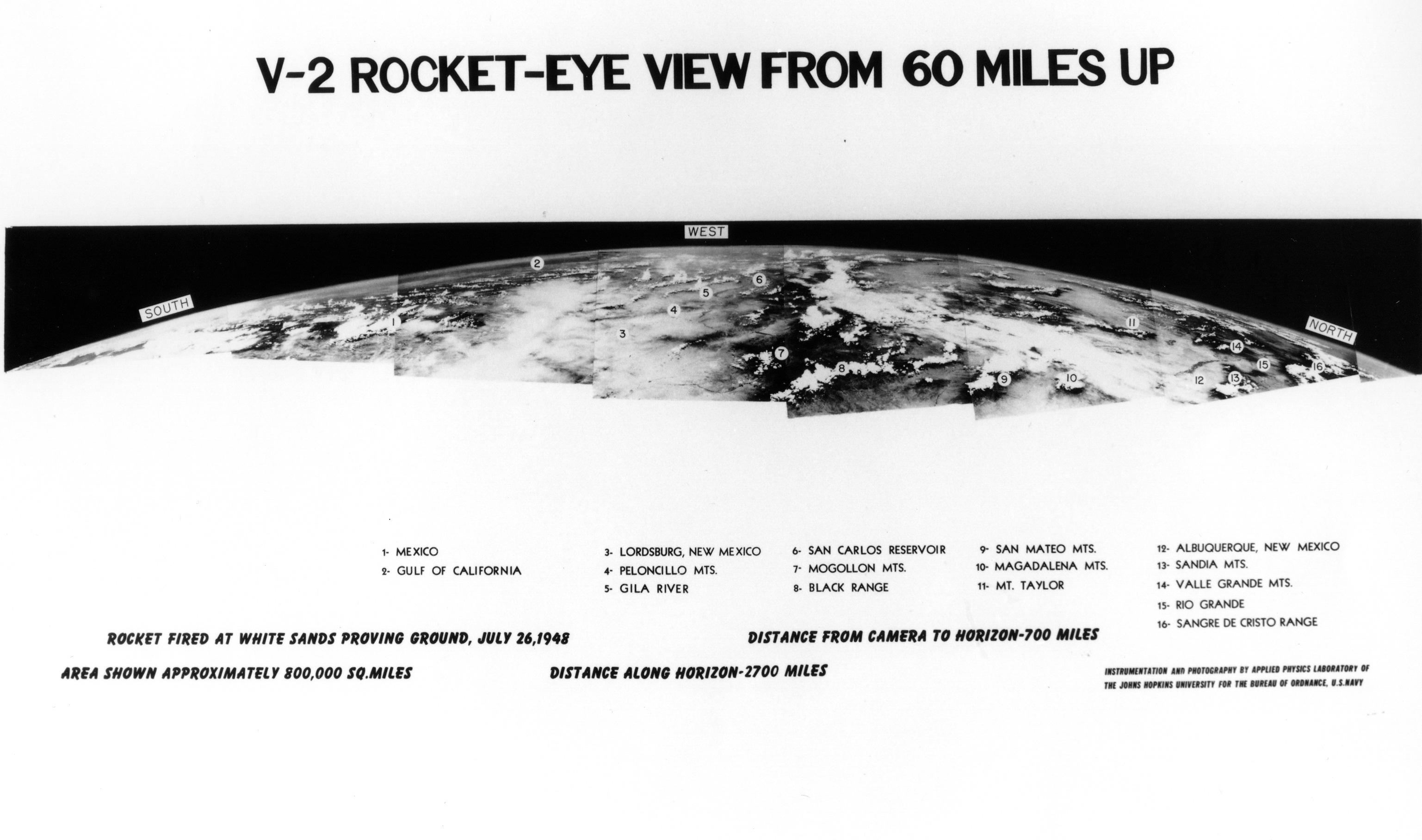
Before 1946, the highest pictures ever taken of the Earth’s surface were from the Explorer II balloon, which had ascended 13.7 miles in 1935, high enough to discern the curvature of the Earth. The V-2 cameras reached more than five times that altitude, where they clearly showed the planet set against the blackness of space. When the movie frames were stitched together, Clyde Holliday, the engineer who developed the camera, wrote in National Geographic in 1950, the V-2 photos showed for the first time "how our Earth would look to visitors from another planet coming in on a space ship." (See a panorama from a July 1948 V-2 shot here.)
/https://tf-cmsv2-smithsonianmag-media.s3.amazonaws.com/filer/V-2-21.jpg)

It was one of many firsts for the V-2 research program of the late 1940s, during which the Army fired dozens of captured German missiles brought to White Sands in 300 railroad cars at the end of the war. While the missileers used the V-2s to refine their own rocket designs, scientists were invited to pack instruments inside the nosecone to study temperatures, pressures, magnetic fields and other physical characteristics of the unexplored upper atmosphere.
Holliday worked for the Johns Hopkins University Applied Physics Laboratory (APL), alongside pioneering space scientists like James Van Allen and S. Fred Singer, both of whom would later be involved in planning the first U.S. satellites. Singer—better known today as a climate change denier with the Science and Environmental Policy Project in Arlington, Virginia—would analyze the photos that came back from the V-2 cameras to determine the rocket’s orientation to the Earth, a job he remembers as "quite difficult." The missile engineers needed to know how the rocket was steering through the upper atmosphere, and the scientists wanted to determine from which direction cosmic rays hitting their instruments were coming. Hardly anyone was interested in what the pictures revealed about geography or meteorology, at least not at first. "We considered clouds to be a nuisance," says Singer.
But Holliday, an instrument specialist at APL, well understood the importance of the photos for the study of Earth. Cy O’Brien, who worked in the lab’s public affairs office beginning in 1950, says Holliday was "in an environment with super-Ph.D.s, and he wanted to make clear that photography was a science, too."
Holliday’s discussion of the photos therefore leaned toward the technical. In those days before Walt Disney and Collier’s magazine planted the idea of space exploration in the public imagination, he was even sparing with his use of the term "space." The V-2 photos, he wrote in 1950, were taken in "the little-known reaches of the upper air." Today, even though the definition is somewhat arbitrary, anything above 100 kilometers (62.5 miles) is considered space.
More than 1,000 Earth pictures were returned from V-2s between 1946 and 1950, from altitudes as high as 100 miles. The photos, showing huge expanses of the American southwest, appeared in newspapers and were scrutinized by scientists from the U.S. Weather Bureau. In his National Geographic article, Holliday offered a few predictions as to where it all might lead: "Results of these tests now are pointing to a time when cameras may be mounted on guided missiles for scouting enemy territory in war, mapping inaccessible regions of the earth in peacetime, and even photographing cloud formations, storm fronts, and overcast areas over an entire continent in a few hours." Going out on a limb, he speculated that "the entire land area of the globe might be mapped in this way."
Fred Rulli, the former member of the camera recovery team, now counts himself lucky to have been in the "select group" that saw the first pictures from space as they came in. At 19, it seemed to him like just another Army job. But he recalls a friend at White Sands, another soldier—60 years later he’s forgotten his name—who was more alive to the future unfolding in front of them. Pointing to the rockets, the scientists and the clear New Mexico sky, the friend would turn to Rulli and say with amazement, "Do you realize what’s going on here?"